Friday, June 30, 2017

AGAIN!! Oregon Curse or Banff Bust

Dee Wright Observatory at McKenzie Pass near Sisters, OR
Tuesday, June 27 - We have had two great days in Deschutes National Forest.  Sunday, we towed the Geo from Prineville to Sisters, OR with no problems and then proceeded to drive the Tracker up to MacKenzie Pass.  MacKenzie Pass is another vocanic lava field.  Ted rode over the pass on our cross-America trip but the road was closed to vehicle traffic at that time due to snow.   At the top of the pass the Civilian Conservation Corps built an observatory in 1935 with markers to identify the surrounding Cascade mountain peaks.  From here one can see North Sister, Little Sister, the Brother, the Husband, both calderas that formed the lava field, Mt. Adams, Mt. Jefferson, Mt. Washington and, on a clear day, Mt Hood.
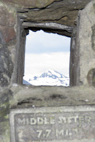
View thru one of the ports
in the observatory

Monday we took a 32 mile bike ride through the forest, into Sisters and then back to our RV. Tuesday morning started with a 17 mile bike ride, again on forest roads.  On both rides we saw bags and bags of pine cones along the forest roads.  Ever wonder where all those pine cones in Hobby Lobby, Michaels and other craft stores come from.   Pine cones are a booming (and backbreaking) business here in the Deschutes National Forest.  Beth stopped and talked with one of the guys bagging them as we left our camp site.  The first day we saw them being hauled away in a pickup with racks along the bed, but this guy had a semi-truck... he was thinking big!

Harvested pine cones... back breaking work
Then it was time to pack up and move on.  As we began the drive into Sisters, we rounded a curve and heard a "bump".  The rearview camera shows that the Geo was loose and weaving behind the RV.  Luckily a side road was just ahead and we could get off the highway.  The tow bar attaches in two places on the front of the car.  Somehow the bar on the driver's side's pin had shaken loose and that side of the tow bar had unhitched.  Because of this the angle at which the tow was now attached, made removing the other side very difficult.   In the process we actually broke the clevis (attachment from the towbar to the car).  Luckily neither vehicle was damaged.  After a short "what do we do now" conference, we decided to drive the RV and Tracker on to Memaloose State Park, just outside of Hood River.  We arrived with no further problems and luckily our campsite (reserved for Weds. - Tues.) was open for the night.

The Oregon Trail curse
Beth thinks this is an Oregon Trail Curse.  When we moved to Oregon in 1989, Beth hated living here because of the rain and short summers.  Now every time we are back in Oregon it seems something bad happens.  On the cross-America trip, Beth backed into a cement pillar in Redmond (on the Oregon trail) and ruining the rear tandem wheel.  Then the jeep burns up in John Day (on the Oregon trail) and now the tow bar is damaged in Sister (on the Oregon Trail).

Ted is blaming the Banff Bust.  This is the third time we have tried to make it to Banff.  The first two times had to be aborted for different reasons. But we are trying diligently to make it this time.
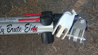
Broken clevis next to the new one
After setting up the RV at the campsite, Ted inspected the towbar and found the damage was more extensive than first thought.  The broken clevis would have to be replaced, but another critical aluminum part was also bent in the main part of the tow bar.  If the part was steel, Ted wouldn't be to worried, but aluminum can more easily fracture after being stressed. So to be safe, we were looking for a whole new towbar.

After consulting the all-knowing internet and ReadyBrake's web site (manufacturer of the towbar) we found a couple of dealers in Portland, but with some not so hot reviews.  However, we already know a great dealer back in Prineville, Daryn at High Desert RV.  So we called Daryn first thing in the morning, he had both the clevis and a whole towbar if needed.  He said he would take a look at the towbar as well and see if he thought we needed to replace it.  So we jumped in the Tracker for the 3 hour drive back to Prineville.  He concurred that to be safe we should replace the towbar.  If we had a few days, he could probably get the parts to fix the towbar, but again we wanted to be on our way, so Daryn sold us the towbar at cost and we were back in business yet again.

The view east from the Rowena view point -
Columbia river gorge 
We were back in Hood River with a little time to spare before picking up Nicholas at the Portland airport, so we loaded up laundry and headed to Jim's townhouse.  Jim came home from work and we had time to do some catching up with him before Ted headed to the airport... or so we thought.  We both misread Nick's arrival time as 6:30, when it was really 5:30 (old eyes), so Nick had to hang out at the airport while Ted made the 60 mile drive.

Jim gave us a great bike route for our Thursday morning ride.  So we watched Nicholas do laps around the campground on his daily run before loading up the bikes and driving 3 miles to Mosier to start the ride.  The ride took us up and over one of the many foothills of Mt Hood which is located to the south and back down to the western edge of The Dalles, then back along the old Highway 30 which leads to a fantastic overlook (with an accompanying climb) at Rowena.
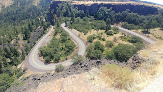

Switchbacks on the climb to the Rowena overlook
Now you might wonder why we had to drive 3 miles to a bike ride when we would normally just ride there.  It is the unique location of the Memaloose State Park where we are staying.  Memaloose is pinned between the Columbia river and railroad tracks to the north, east and west and I-84 and a shear rock cliff to the south.  The ONLY entrance to the park is from the west bound lane of I-84 which is not exactly where we want to ride a bike.  Plus to return to the park from the west, you have to go 3 miles east of the park on east bound I-84 to Rowena, exit and then get on west bound I-84.  It is NOT what I would call easy access, but it is July 4th weekend and we didn't have a lot of options.

Sunday, June 25, 2017

Big bike, little car

Friday, June 23 - After the stress of the last two days, we really needed to get out for a ride.  We decided to ride out to the Prineville Reservoir and back, a 32 mile trip with 2300 feet of climbing.  It was a beautiful morning and a great ride.

Steins Pillar
As we were climbing out of Prineville, we took a quick stop to answer the call of nature where a side road came up to the main highway.  A truck came down the side road and caught Beth literally with her pants down.  The driver waved and went on.  Why are we sharing this embarrassing story?  About an hour later, after making it out to the reservoir and on the way back to town, we again were pulled over on the side of the road.  The same truck pulls up and the older "gentleman" asks whether we need "paper".  No, Beth's pants were up this time.  He then proceeds to tell us that "protocol" involves covering your face with both hands when caught in that compromising position.  He learned this when he was driving across the Mojave desert and anyone caught in the "call of nature" position" did just that.   Just an example of how friendly the central Oregonians are.  On this same ride, we had a truck slow down and offer to take us to the top of the climb.  It was a 5 mile long, ever steeper climb, but we knew that going in.  He didn't seem to quite understand the bicyclist masochistic tendency to go look for steep climbs and the creed of you must climb it to earn the "Wheee!!" back down.

After returning from our bike ride, we needed to visit Oregon's MVD.  For $30 we were able to get a travel permit for the GeoTracker, thus making it a legal vehicle until we get back to NM to register it there.  Again a fairly simple process and amazingly quick for how busy the MVD was on a Friday afternoon.  It's amazing what new information we have learned on this trip.

Big bike, little car
We were still waiting for a call from Daryn at High Desert RV letting us know the tow bar adapters for the Tracker had arrived.  At about 3:30 a call came in, the parts were on a truck that had broken down in Redmond, a small town about 17 miles away.  Daryn didn't have anyone that could make the trip to pick up the pieces but if we would go pick them up, he would help us attach them.  Ted made the trip and got the parts without incident.  Daryn then drilled the necessary holes and bolted the attachments to the Geo's towbar.   He refused payment for the parts or his time working.  Again we cannot thank him enough for all the help he provided.

Saturday, June 24 -  We needed to test how the bike rack would work on the Tracker, so we loaded up the tandem for a quick trip out of town.  The hitch on the Tracker is closer to the ground and the tandem can drag going through short dips, most frequently pulling out of gas stations onto the street.

It turned out the road next to where we bought the Tracker, 10 miles out of Prineville turns into a forest service road.  So we drove there with the tandem on the rack without a problem and found a pull-off to unload the bike. A 24+ mile ride with 900 feet of climbing took us through a farming valley and then into national forest.  Again the morning and scenery were gorgeous.  Along the way we passed Steins Pillar, a 350' high volcanic spire.

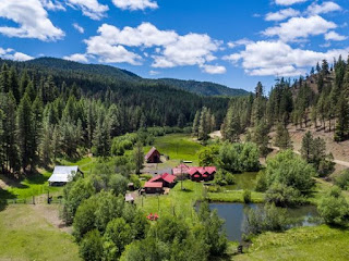
Photo of property for sale from their Zillow listing...
Price reduced to only $1.75M
Not much further up the road, but 10 miles from the highway and 5 miles of OK dirt road, we passed a small house with a couple of guest cottages and 2 ponds which was all very well kept.  It was for sale so we stopped to take a look at the property info that was posted next to the "For Sale" sign... Only $1,990,000 asking price for the 185+ acres with a mile of stream frontage, house, cottages, ponds, out buildings, etc.  Even if you could rent it out for watching the solar eclipse in Aug, which is a HUGE deal here in central Oregon, it would be a tough sale.

And speaking of the solar eclipse, people are renting out their front yards for camp sites at $200-$800/night with a two night minimum around August 21.

Anyway, we couldn't have asked for a better morning.  Ted needed to purchase some brake and shift cables to accommodate the change in how the bike will be mounted on the rack to get it higher off the ground.  He wants to turn the handle bars backwards which needed just a couple  more inches of cables to twist it around.  The afternoon was spent with Ted working on the bike and Beth working remotely for her contracting company, EASi.


Thursday, June 22, 2017

Serendipity

Serendipity:  the faculty or phenomenon of finding valuable or agreeable things not sought for

Thursday, June 22, 2017
Picking up from our previous post, "Fire - The Jeep is Toast"...

We spent much of the evening and some of the early morning hours discussing next steps for our trip now that we had a 3700 pound bike rack holder sitting behind the RV.  Before the fire we had planned to move on to the Bend, OR area and do some bike riding on the many forest roads and EASY single track mountain bike paths that are in the Mt Bachelor area.  Jim and Heidi were even considering making a trip down for the weekend to show us some of their favorite rides.  But we had put that all on hold to deal with our destroyed Jeep.  

We had contacted Ben to go to our house in ABQ to get the title for the Jeep and send it to Jim so we would have it in the next week or so.  I had called a local RV/auto repair shop to have them take a look at the Jeep just to confirm my "it's totaled" assessment.  I was pretty convinced that it would be a real project to repair with all of the systems that were damaged by the fire... cooling, brakes, AC, heater, fuel injectors, radiator shroud, air filter and intake ducting, multiple electrical wire harnesses and cruise control.  And that was what was readily apparent.

We packed up the RV, removed the tandem and bike rack from the Jeep, cleaned the Jeep of any personal stuff (Beth was really hoping it wasn't coming back) and headed out.  Beth had found a laundromat in town so she did laundry while Ted went to talk to the mechanic.  

I (Ted) pulled into High Desert RV and Auto Repair and checked in at their front desk.  An older gentleman came out to take a look at the Jeep and sadly told me about his Jeep Cherokee that had done the same thing while he was driving it across Wyoming.  He had put the fire out with a gallon of ice tea.  Obviously this is not an infrequent occurrence with Jeeps.  His best guess was probably $8000 to get it back in running shape which is about the Blue Book wholesale value of it.  He said we should have Daryn take a look since he is more of the auto mechanic.  So Daryn came out to have a look as well... The consensus was pretty much "OH MAN... What happened!"  

I asked Daryn if there was a salvage yard in Prineville that might be willing to take it.  Daryn (who owns the shop) said if I wanted to get rid of it, he would take it and gave me $400 for it.  Considering I would have given it to him to lighten our load, it was "Serendipity #1" and Beth's wish answered.    

While he was looking at my towing setup he said he really likes my "ReadyBrake" towing/braking system.  He has been installing them for several years and are the best system he has found.  That was good to hear since I was a little worried about it after seeing smoke come off the RV brakes after a long, 8% grade descent in the Colorado Rockies.  I had done some adjusting to the cables that actuate the brakes after that and the Jeep brakes seemed to be more effective from then on ... at least the Jeep front disk brake rotors where hot when I checked them after some long descents.

I told Daryn I wanted to keep the cabling for the brakes system.  He said he would just give me all new braking cables since he was a dealer and had them in stock.  It would save the trouble of removing them.  "Serendipity #2"

Since Daryn was being very helpful and was very knowledgeable about RVs and towing, I asked him what he thought of the Chevy Equinox as a tow vehicle.  We used to have one, know it is a good cross-over vehicle and gets good reviews from other RV'ers and far more reasonably priced that Jeeps. He said he hadn't ever installed a towing system into an Equinox, but pointed me to a website that lists good tow vehicles.

He then proceeded to ask "Have you ever looked at Chevy Geo Trackers?"  I said I had looked, but they haven't been in production for a number years and finding one that wasn't completely beat up was very hard.  Daryn goes on to tell me that there is a 1995 Geo Tracker for sale in Prineville completely set up to tow with only 80k miles on it.  He has considered buying himself since he collects them (he has 7 of them), knew it was in excellent condition and had the phone number of the guy selling it.  "Serendipity #3"

I went to collect Beth from the laundromat and discuss my good fortune of the morning.  Beth would been thrilled with just getting rid of the Jeep, much less getting $400.  Over a lunch of bar-b-que brisket from a semi-permanent food truck, we decided to call and see if the Tracker was still available.

"New" '95 Chevy Geo Tracker  (no burn marks on the hood)
Glenn, the 80+ year old owner of the Tracker, said it was still available and we could come look right then.  He lived about 10 miles out of town right on Highway 26 and we had driven by his place the day before.  A quick 10 minute drive and we were in Glenn's front yard looking at his red Tracker.  As I took a quick look, you couldn't have asked for much more.  It was set up for towing, not exactly a match to our tow bar, but he had a tow bar that would only require us to buy a 2" ball for the RV (I have to at home in the garage of course).  The rear of the Tracker had a 2" receiver hitch which is exactly what we need for the bike rack and it had a roof rack to tie down the bike rack... it was checking lots of boxes.  I had very little concern about the engine since Daryn had checked it out, but Glenn and I took a quick drive just to see how it ran.  It was plenty good enough for a tow vehicle and was more comfortable than the Jeep. Beth and I looked at each other and said let's buy it.  At $4700 we weren't going to be out too much money, well at least not in the scheme of things.  "Serendipity #4"

Hard to see the  2" rear trailer receiver for the bike rack
Glenn's one condition of the sale was he wanted cash.  Well you wouldn't think that would be too big of a problem, but it proved to be the most difficult issue of all.  Not that we don't have the money sitting in our credit union back in NM.  We keep a pretty healthy emergency fund for these trips.  But it is getting cash that proved to be more of a problem.  After visiting 2 credit unions in Prineville it was clear that cash from a CU was a problem.  Cashiers check, no big deal, but cash was going to be limited to maybe $2000 in a given day, even if you were a local member of that credit union.  We have a Chase credit card and there was a Chase bank in town, so we headed there.  After looking at multiple options, we checked the cash advance limit on the credit card... $4400 and with the $400 that Daryn gave me for the Jeep, we were there.  "Serendipity #5"  The interest rate for a cash advance is insanely high, so that thing is getting paid as soon as it posts to the account.

We had agreed to meet back at Daryn's RV/auto repair shop to do the exchange, money for title and car.  As we are signing the papers and handing over the cash, Daryn comes out to see how things are going.  We were both glad that he put us together to solve our problem and replenish Glenn's fun money.   Turns out Glenn did not get the money, his wife did because it was her car and the cash disappeared into her purse.  Daryn looks at the tow attachment on the Tracker and said he could get us the right adapter for our tow bar by the next day if we wanted.  Since Beth had already arranged another night in the RV park this was working out quite well.  "Serendipity #6"   So yet again, things just keep falling into place.

So then all that's left to deal with is registration back at NM MVD. Insurance was handled online.  Oregon will allow you to purchase a vehicle transfer permit that is good for 21 days so tomorrow in addition to getting the tow bar adapters, we will most likely be at the OR MVD office and doing some practice towing while we have access to maybe the best RV shop we have found anywhere.

What a turn of events and we got to meet some really nice, friendly and helpful people here in central Oregon.


Wednesday, June 21, 2017

FIRE!! The jeep is toast!

Overview of the Blue Basin in John Day Nat. Monument
In the Blue Basin
Weds, June 21 - Due to the time change we got a very early start from the Clyde Holiday State Campground,  A good breakfast stop was found in Dayville at the Dayville Cafe.  After plates of eggs, toast, biscuits & gravy and hashbrowns we couldn't finish, we were presented with the "pie list".  Now if you know Ted you know he cannot resist homemade pie, so a takeout slice of freshly made apple pie was in order.  Along with the pie came the waitress' recommendations for hiking and overlooks in the Sheep Rock Unit of the John Day Fossil Beds.  Our plan had been to hike the Blue Basin trail (4 miles) which was confirmed by the waitress as the best way to start the day.  Since she lives in the area, she suggested that we drive by Cathedral Rock (not worth stopping) and continue on to Foree Area, which had two short trails.  

Our first hike went off without a hitch.  The formations are volcanic ash from the Cascade mountains with a bluish/green color and look like hoodoos due to the erosion that has occurred.  Many of the fossils found in the area are made up of material that was buried in the layers of volcanic ash.  The fossil beds are dispersed across 20,000 square mile of eastern Oregon.  Exploration and study have continued since the late 1800's and new fossils are still being found today.

We then left the RV in the parking lot and took the jeep to the Foree Area about 3 miles down the road.  As we turned into the parking lot, we both commented that it smelled like someone had a wood fire.  We parked the jeep and walked up the short Story in the Stone trail, sat on a bench to view the surroundings and saw smoke!!  And it was coming from our jeep!!   Ted took off at a run and by the time he got there it was clear that we had an engine fire!

Luckily someone else in the parking lot had a fire extinguisher and we were able to put out the fire.  But the jeep is toast, literally!  The couple who had the fire extinguisher took Ted back to our RV and we were able to push the Jeep around to where we could hook it up to the RV tow bar.

The rest of the trip went without incident to our stop for tonight - Crook County RV Park in Prineville, OR.  Our original plan was to stay in Mitchell, OR, a former trans-America bike trip stop, but we needed to get to where we had cell phone/internet service and a chance to figure out what to do with the jeep now.

After a little internet searching, Ted found an article with a very similar picture of another Jeep with an engine fire.  They had found a fuel injector with with a cracked O-ring leaking gas onto the engine.  Our fire seemed to start at the fuel injector as well.  There is considerable burned wiring, 2 fuel injectors are completely melted, the AC hoses are cracked, the brake and radiator fluid reservoirs are melted, the air filter canister is melted, heater hoses are burned, the radiator shroud is melted around the radiator fan, and who knows what else may be damaged.

Tuesday, June 20, 2017

Sun Valley, ID to Eastern Oregon

The Harriman bike and x-country ski trail near Sun Valley, ID
Sunday, June 18 - Time to do chores again so a short drive into Ketchum (the actual town at Sun Valley) for breakfast at the Kneedary and then on to Laundromutt for laundry.  Yes the laundry we found was both a laundromat and a dog groomer.  But being Father's day, Sunday, the groomer had the day off and it was a mutt-less laundry experience.

Then back to the RV for a 26 mile out and back ride along the Big Wood river which included about 16 miles off road path (The Harriman trail).  Some of the trail was closed due to the river being out of its banks.  Snow melt runoff is very high here in Idaho (along with most of the Rockies) with signs of flooding (sandbags, trail damage, etc).   One more night at this beautiful camp spot and then time to move on.

Bully Creek Reservoir 
Monday, June 19 - We packed up the RV and rolled about 125 miles toward Boise, ID.  A stop in Nampa, just outside of Boise, allowed us to finish our list of chores (groceries, gas and propane).  Then we headed across the Oregon state line to Vale, OR and Bully Creek Reservoir County Park.  We picked a camping place with electricity since have left the cooler temps of the mountains behind and will be at a much lower elevation and will need to run the air-conditioner.   While we had a shady spot at the camp ground the temps were in the high 80's and had to run the air-conditioner.

One of the down sides of the Bully Creek Campground was reports of arsenic in the water.  We had read about this in one of the campsite reviews before coming, so we had used one of the many free waste dump and water sites scattered throughout Idaho at the city park in Fairfield.  Beth had picked up a handy book that listed all of the free sites in Idaho a few days ago.  This is a state wide program funded by the RV registration fees in Idaho and free to all RV travelers in the state.

The row of turbines used to generate electricity
at the geothermal power plant.  The large pipe carries the
hot water from the underground source
Tuesday, June 20 - Our morning started with a 13 mile out and back bike ride down the dirt road outside of our campsite.  We had planned on a longer ride but ran into private land in one direction and a creek flowing over the road in the other.  Not wanting to get wet and muddy, we cut the ride short.  Along the way we passed a geothermal electric plant which was relatively new (Nov. 2012 according to a Google search).  It is not a huge power plant but produces enough electricity for 24,000 homes, only takes 12 people to operate and has nearly zero emissions.  The EPA helped secure the funding for it (prior administration) and it has a Canadian private investor.  You can read more about it here

We are currently camped in an Oregon State Park outside of John Day.  Again we are thankful for electricity as the air-conditioning is a welcome relief from the heat.  We rode through this area on our cross country bike trip 4 years ago and wanted to come back and see some of the parks and monuments here before we move on to Bend, OR later this week.

Saturday, June 17, 2017

Continuing West - Craters of the Moon National Monument

Wild flowers in Craters of the Moon Nat. Monument
Friday, June 16  - Thursday morning we took a 10 mile bike ride (5 miles down; 5 miles up) before leaving our BLM camping spot.  It’s preferable to ride uphill first and coast “home” but when you are camped at the top of a ridge that’s pretty much impossible.  Our drive took us in and out of Utah and Wyoming near Flaming Gorge National Recreation area with our final camping spot on Bear Lake on the Utah/Idaho border.  Bear Lake is a very large oval shaped lake (20 miles long and 7 miles across) with state parks scattered up the east side, so lots of camp sites available, water activities and mosquitoes. And the lake was very full with not much beach and some areas flooded.

It was back on the road with a stop in Pocotello, ID for a few supplies including a 12 ton jack just in case we have to jack up the RV again because of a stuck leveler.  My poor little jack from the Jeep could barely compress the spring on the front wheel, so it would be useless if we had to jack up a rear wheel.

Wild flowers on the volcanic cinders
After two fairly long driving days, we camped in Arco, Idaho just outside of Craters of the Moon National Monument.  Our home for the night is Mt. View RV park.  Although Craters of the Moon has one campground it is on a first come basis and since it was already late Friday afternoon we decided not to chance it.  As we were checking in at the RV park, the campground hosts from Crater of the Moons were at Mt. View office, asking how many spots were left at his park because they were already full.  Very glad we did not count on getting a spot.  Tomorrow we plan to explore the monument and get in some hiking, biking or both from the paved loop road.  

One of several of the volcano craters
Saturday June 17 - We spent the morning exploring Craters of the Moon National Monument, established in 1924.  This giant lava bed is similar to El Malpias near Grants, NM or the lava flows in Hawaii. Craters is the "most recent fissure eruption" in the continental US.  

Once we reached the visitor's center, we unloaded the tandem for the 7 mile loop through the monument.  With the out and back spurs our ride was only 10.7 miles total but we stopped at several trail heads and overlooks for short hikes.  We hiked to the top of Inferno Cone, which reminded us of Dune 45 in Botswana from our trip to Africa last year, only black cinders instead of orange sand.  Mid-June is the peak of the annual wildflower blooms and it was quite startling to see a "pink carpet" of Monkeyflowers across many of the cinder beds.  All in all a remarkable place.

People walking up Inferno Cone
A short drive took us up into the mountains of Sawtooth National Forest, just outside of Sun Valley, ID.  We are camped just inside the boundaries of the national forest within 100 yards of multi-million dollar houses.  We are in a meadow overlooking a flowing stream and a very expensive neighborhood.  Based on a quick Zillow search, our RV is located on land worth approximately $600,000/acre!... and we are camping here for free!  And it is gorgeous!  And we can't see another campsite from here.  We have it all to ourselves.
Our camp site on national forest land just outside Sun Valley, ID.  The multi-million dollar houses are just beyond the RV

Wednesday, June 14, 2017

Dinosaur National Monument... Panic... Call to AAA

Camp site on BLM land outside of Dinosaur National Monument
Tuesday, June 13 – A 20 mile ride around Olathe, CO through cornfields and cattle corrals started our morning.  Olathe is known for it's sweet corn, but way too early for any local produce.  A quick stop in Grand Junction at REI for socks, gas fill-up and a quick lunch at a truck stop broke up the drive to Dinosaur National Monument on the Colorado side near Dinosaur, CO.  We had located a free campsite using our new best website, Campendium.  We found a site on
BLM land and adjacent to Dinosaur National Monument with 360 degree views over the San Juan Valley. 

Green River heading west in Dinosaur Nat. Monument
But then disaster struck!  One of the REALLY nice features of our new RV is it has automatic levelers which can level the RV (within a limited range) to allow the slideouts to extend, keep the refrigerator running, keeps the toilet lid from falling at an inopportune moment and you don't slide out of bed.  No driving up on a stack of blocks to try to get it close to level.  HOWEVER, they can be a little finicky.  If the ground is a little uneven, then they will frequently give an error code without leveling.  

Anyway our parking spot was not the flattest and a mix of gravel and rock.  When we leveled the RV the front left (driver's) wheel was completely off the ground and the leveling foot looked slightly twisted.  It was very windy, so we thought we should find a more level spot so that all 4 wheels were on the ground.  We tried to retract the levelers, but the drivers side front left would not retract.  We tried several times, but here we were with one wheel stuck up in the air and a leveler soundly driven into the ground.

To try to take some of the pressure off the hydraulic piston that does the leveling, Ted got the jack out of the Jeep and the leveling blocks (old school leveling method), jacked up the wheel and put blocks under it.  Then Ted crawled under the RV with a camping shovel to try to dig out the area under the leveler to remove all the pressure.  After 30-45 minutes of digging in the rocks and gravel, we tried again to retract the leveler... still no luck.  Time to call AAA.  We have their RV coverage just for this reason.  They were very helpful but the closest tow would come from Rangely, CO about an hour away.  The serviceman was out of town, and an hour in the other direction, so we agreed we could wait until morning for help.  

The convergence of the Green (upper left) and Yampa (top center)
Rivers.  It is the Green river after they merge (lower left)
Supper was the next item on the agenda and a phone call to our son, Ben.  While we are the phone, we heard a loud "POP" and the left front of the RV dropped a little since we still sitting on the leveling blocks under the front wheel.  The leveler had decided to retract!  We were able to retract it completely, move to a more level spot and with a block under each leveler, set down and retract the levelers several times.   We were back in business!  Lesson learned - on rocky ground get as level as possible before extending the leveler (buy a bubble level at next stop instead of using a glass full of water) and put a plastic leveling block under each leveler before extending in case there is a buried rock in the mix of gravel.

Petroglyphs in the canyon
Weds., June 14 - Time to explore the canyons on the eastern end of Dinosaur National Monument.  We drove to the end of the road and took a 2 mile hike to a prominent overlook.  From here you could see where the two rivers (Yampa and Green) that form these canyons converge.  If you want a very private experience in a national park area, this is the place to come.  We saw three people and 5 cars during this time in the park.  Our next destination was Echo Campground on the river.  A steep, dirt road with tight switchbacks takes you into the canyon.  The signs expressly restrict RV's, trailers and discourage passenger cars.  Our 2001 manual transmission Jeep made it with no problems.  It was well worth the drive.  In addition to the canyons walls and the riverfront area, we say some very unique petroglyphs and an old homesteaders house and cabins.  Along the river, a group of rafters had pulled in for lunch. We also saw a couple of cars and met one other person hiking.  

A good sized group of float trippers on both sides
of the canyon
We are sharing our camping spot with a very nice couple from Canada tonight.  And then some very unusual visitors, a herd of cows with a very noisy bull decided to check things out.  Welcome to the Wild West and BLM land camping!


Monday, June 12, 2017

Black Canyon of the Gunnison NP, CO

Friday, June 9 –
Head waters of the Rio Grande with the
Rio Grande Pyramid in the background
We had designated this as mostly a travel day and had chosen a route through the San Juan mountains of southwestern CO.  This is a route to the park that we had not traveled before.  This is getting harder to do as so many of our trips head to the northwest.  We drove through Creed, CO, an old mining town.  Unlike so many of CO’s mining towns that mined silver; Creed is the only town that mined bentonite clay.  The clay was used in refining oil and frequently used as a desiccant (water absorber) for guns and ammunition and in the production of make-up and salt water taffy.  The mine went out of business in 1999. 

A pullover on one of the mountain passes outside of Creed gave us a view of the Rio Grande Pyramid.  Ever wonder where a river starts?  For the Rio Grande, it is here.  A new fact for us is that the Rio Grande is the third longest river in the United States (1885 miles) after the Mississippi and the Missouri.   We have now been to the headwaters of all three. 

Our campsite at Black Canyon NP... just the length of our 28' RV
This has been a year of the Rio Grande for us, having visited Big Bend National Park in TX (wanted to check how Trump's wall is coming) in April, spending a week at Bandelier National Monument (Los Alamos, NM) in May, both parks are bordered by the Rio Grande, camped next to the Rio Grande in Del Norte, CO and now visiting the head waters… plus we live less than a mile from the Rio Grande in ABQ.

Late in the afternoon we entered Black Canyon of the Gunnison National Park.  Being one of the lesser known national parks located near Montrose, CO and being hard to get to (at least from NM), we were not anticipating any trouble finding a spot in the campground.  Especially since 1/3 of the spots can’t be reserved.   To our surprise the camp was almost full.  Every “reservation” spot was
taken and we were lucky to find an open, fairly level spot that was just barely big enough for our 28’
Painted Wall at Black Canyon, the tallest cliff in CO at 2300'
from top to bottom
RV in the first-come/ first-served loop.  By that evening the campground was full.  A note to the wise; arrive early or better yet, make a reservation.

Saturday, June 10 – We set out on foot for the 1 mile walk to the Visitor’s Center, followed by a 2 mile loop just below the rim, finishing back at the campground for a total of 4 miles.  When we returned to the campground, many of the other campers had left and the remaining people were moving around to better locations.  We were able to move the RV to a location that had fewer trees, making it easier to put out our slide outs.

At the bottom of Black Canyon near the
Gunnison diversion tunnel
In the afternoon, we drove down a steep set of switchbacks at the east end of the park to the Gunnison diversion tunnel.  The tunnel was drilled starting in 1909 and is 10,000 feet long through solid rock to the valley near Montrose.  The tunnel was drilled from both ends and met in the middle.  Quite the engineering feat for the time.  These are some seriously steep canyons to work in.  After our visit to the diversion tunnel we drove the south rim road, stopping at the Visitors Center and the many pullouts to walk out and look down the canyon.

Sunday, June 11 – Our plan for the day was to drive to the north rim of the canyon.  From the campground it’s a 2 hour drive, backtracking some of Friday’s drive on  Hwy 50 before turning onto Hwy 92.  East of the national park is a reservoir (Blue Mesa) which is part of Curecanti National Recreation Area.  The drive to the North Rim was scenic.  And the canyon view from the north rim were spectacular.  The dirt road runs right along the rim and any pullouts brought you to the edge of the rim.  We really enjoyed the views from this side much more than the south rim.  It is a wild and rugged canyon and you can see why no signs of any human habitation have been found in the canyon.  Any activity within the inner canyon, including hiking, climbing and kayaking, require a wilderness permit and is highly discouraged unless you are an expert.

A deer with no fear... came to visit several times
We have had visitors to our campsite both early evening and early morning.  The deer are unafraid and will walk right up to the RV.  The first night we had taken the bike rack off the jeep and put it on the ground in our campsite.  A very curious deer decided the straps were quite tasty.  We had to remove all the straps and tiedowns from the rack as we were afraid they would be chewed in two.  You can see from the picture how close the deer come. 

Monday, June 12, 2017 – After one more night at the campground, we biked the south rim road.  Although only a little over 14.5 miles round trip, we climbed over 1400 feet at an average elevation of 8000 feet.  Quite a nice early morning workout.  Then it was onto the task of packing up everything, putting the bike on the rack and hooking up the jeep for a short drive to Olathe, Colorado and the Uncompahgre River RV Park.  We had stayed here once in the past and remembered it as a nice place with good laundry facilities.  The rest of the day was spent taking care of the multitude of chores (laundry, grocery shopping, bug removal from the front of the RV, Beth is still working remotely, etc) that have built up when you have been on the road for 7 days, either boon-docking or in the national park with limited services.  It seems a little odd to have pressurized water, 115VAC electricity, WIFI and cable TV available.
At the high point of the south rim road

Thursday, June 8, 2017

Desert of the Christ Benedictine Monastery

Christ in the Desert Monastery
Weds., June 7 – Our morning started with a 30-mile round-trip ride to the Christ in the Desert Benedictine Monastery.  Secluded in the desert down a 13 mile one lane dirt road along the Chama river, it is beautiful location.  Of course, we know of it because of its unique funding stream.  They grow their own hops and brew their own ……wait for it……Monk’s Ale made with care and prayer.  Sadly there is no tasting room at the monastery, but we did pick up a six-pack of Monk's Wit in Chama. 

After the ride we showered and broke camp at Echo Amphitheater. We traveled a short way down the road to Cumbres Pass north of Chama.  This is where the continental divide bike trail heads off toward Abiquiu, NM.  There was still snow pack and mucky roads.  Russ (Ted's riding partner for the Cuba to Columbus ride) had talked about starting here.  I am glad we (me) decided to pass on trying to tackle this section.  We ran into a couple who tried to cover this section in their Jeep and failed for mud and downed trees.  It would have been a very ugly ride.

We moved on a few miles to Elk Creek Campground just across the NM/CO border to spend a chilly night at 8500' of elevation.

Conojos River Valley near Horca, CO
Thurs., June 8 – Again we started with a bike ride.  Today an out and back of 20 miles on part of the Continental Divide route.  We followed the Conojos River Valley.  It’s amazing how much water we are seeing in the creeks and rivers compared to when we were in this area last fall.

Then into the RV and again a fairly short drive to Del Norte, Co.   This location was picked because the city has a free dump station, water and a one overnight camping in the park.  Our next stop will be Black Canyon of the Gunnison National Park for several days and no water is available in the park, so we needed to dump the waste tanks and refill the water before moving on.  

Tuesday, June 6, 2017

Summer 2017 Adventures

June 6, 2017 – After several days of packing up the RV for multiple adventures, we hit the road mid-morning.   The first part of our trip is totally unplanned; a wander toward Hood River, OR.  For those of you who don’t know, our oldest son, Jim, left Boeing in Seattle and has moved to Hood River to work for a new company, Insitu, which is also owned  by Boeing but is operated as a separate wholly owned subsidiary. 

New Motorhome setup
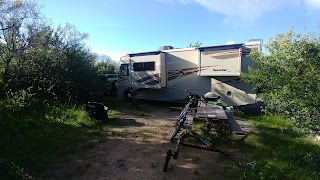
Late last summer we sold our 2007 Winnebago Navion (Mercedes Sprinter) motor home and bought a brand new 2017 Winnebago Sun Star LX 27N motorhome.  It is 5' longer than our older one, but still only 28' long plus 3 slide outs which make it more of a "tiny house".  We have a queen sized bed in the back, a nice kitchen area, a bigger dinette and TONS of storage.  We are also pulling a 2001 Jeep Wrangler with the bikes on the back for getting off the beaten path.  We have taken several shorter trips with the motor home and REALLY like it.  We had to give up the Mercedes diesel engine that got 15mpg, for a Ford 10 cylinder gas engine that gets about 8mpg, but so far we are very happy.

Our nephew, Nicholas, sometimes summer support driver, traveling companion, and all around good kid (now young man) is flying into Portland, OR on June 28th to join us for the second part of the trip.  The plan is to spend time in Hood River with Jim and Heidi, then Seattle, Jasper and Banff.  Ted plans to leave for his Continental Divide trip on July 12th from Banff for all points south to NM.  Nicholas and Beth will then take the RV and head to MO to visit with relatives.   Beth will then drive the RV back to ABQ to return to work.  Ted should make it to the CO/NM border toward the end of Aug. or first of Sept.   We will joint blog for the first part of the trip.  Ted will then draft his adventures whenever he can for Beth to post.  Beth will continue to post until Ted finishes.   So, check in frequently from now to Sept.


Echo Amphitheater just in front of the RV
With no particular destination in mind other than the Black Canyon of the Gunnison National Park sometime this week, we started north.  Our stop tonight is at Echo Amphitheatre north of Abiquiu, NM.    We have stopped here when the kids were young on our way to or from Wolf Creek for skiing.  Echo Amphitheatre is a semi-circular
natural rock formation that (of course) echoes what is said in front of it.  Our campsite looks south toward the Jemez Mountains and a better view could not be found.