Sunday, August 26, 2012

One Last Ride - Arches National Park, Moab, UT

Arches National Park - Moab Utah
We left Seattle on Thursday morning and drove to Boise, ID for the night.  We thought about a short ride in Boise, but it was pretty chilly and a lot of smoke from local forest fires changed our mind.  We hit the road and stopped for dinner in Moab, Utah.  We were really surprised by how few people were in town.  We had spent a few days in Moab a couple of years ago and the streets we packed and the hotels were full.

Beth and I were both tired of being in the car, so we decided to spend the night in Moab.  We had no problem finding a room with town being so empty.  We knew we could get a nice ride in at Arches National Park before we left and still get back home by late afternoon.

We drove into the park a couple of miles... the first 2 miles is a grinding climb with little to look at.  We unloaded the road tandem and road out past Balanced Rock and on to Window Rock... and back.. 19 miles total.  It was a great ride to finish our trip.  More Photos

We made it home with no problems to find weeds 4 feet tall in the driveway and a box full of junk mail.  Nice to be home, but this was an absolutely fantastic trip and we can't wait for the next adventure.

A few stats from the trip:
31 days on the road
4900 miles on car odometer
22 bike rides:
  825 miles on the bikes with 58,180' of climbing
7 National Parks:
    Mt. Evans; Rocky Mountain; Grand Tetons; Yellowstone; Mt. Rainier; Olympic Peninsula; and Arches
954 photographs...


Last Ride... this trip...

Thursday, August 23, 2012

Port Angles, WA

Cory, Harper, Marci and Jason
On Sunday, we met up with Jason and Marci from Kansas City.  We met them on a Bicycle Adventures tour of the San Juan Islands 6 years ago and have done several cycling trips together since.  It has been a little different this time.  We haven't done a trip together since Harper was born 20 months ago.  Cory, Harper's nanny came along to take care of Harper while we were riding and provide sag support to us.  It all worked out really well and we had a great time together.  (Photos of our excursion to Port Angeles)

Sunday morning we picked up their rental bikes and went for a ride on the Burke-Gilman trail along the edge of Lake Washington in Seattle just to try out the bikes and make adjustments.

Jim and Heidi had borrowed a "pack'n play" and Burley trailer from friends for Harper and they loaned us their 4Runner as a second car for our trip out to Port Angeles.

Dungeness State Park
Monday morning we met up at Marci and Jason's hotel near the Space Needle, packed up the cars and headed to the ferry for Bainbridge Island.  We made a stop at Bainbridge, walked around town, went to the play ground and had some lunch before heading out to Port Angles.  We made a stop at the Dungeness State Park near Sequim (pronounced something like Skwim).  Since it was a clear day we could see across the Strait of Juan de Fuca to Victoria, BC.

Lake Crescent
Tuesday we did the ride out to Lake Crescent and this time we got to see the lake.  It is a pretty lake, but it was overcast and a little chilly, so we had lunch and headed back to town.  Highway 101 is the main highway in the area with some logging truck traffic.  We had remembered being sprayed by the trucks in the rain the first time we did this ride, but today, the traffic was fairly light and only one incident of a logging truck getting "a little close".

On Wednesday was the big climb up to Hurricane Ridge in Olympic National Park.  This is a 20 mile ride from Port Angeles (sea level) climbing up to 5200'.  It was a mostly sunny day for the climb with great views.  There were a few clouds on the descent and it got pretty chilly going 35-40mph even with a raincoat on to block the wind.

We had a great dinner in Sequim at the Alder Wood Bistro... if for some reason you find yourself in Sequim be sure to have dinner there.  It came highly recommended and did not disappoint.

We are all back in Seattle now.  Beth and I are spending a final night at Jim and Heidi's house repacking for our trip back to New Mexico.  We can't thank them enough for letting us use their house for staging, storage, stop-overs, a loaner car and rounding up baby support equipment from friends during the last 2 weeks.  Luckily we will get to recipricate soon as they make a trip to NM for 2 weddings and some mountain biking in NM, Colorado and Utah... or at least that is the plan.  The car and bike rack are ready to go.

Time to head for home and get back to work for a while, but we are already planning the next big trip... this one has been fantastic!

A panoramic view of Hurricane Ridge that Jason took with his iPhone using AutoStitch

Saturday, August 18, 2012

Back in Seattle... for a couple of days at least.

We finished up our stay near Mt. Rainier on Friday by driving to the south side of the park to Reflection Lake, taking a few photos and then hiking the Pinnacle Peak trail... I should really say climbing the trail.  It is 1.4 miles long and 1300' of climbing to the saddle where the maintained trail ends.  It is pretty much like walking a stair stepper all the way, but of course great views of Mt. Rainier, the wild flowers, waterfalls, and eventually Mt Adams to the south when you reach the end of the trail.

The last half mile or so of the hike was traversing a rock slide several times.  A lot of work went into building and maintaining this trail.  At one point there is at least a 200' section of trail where a 5' high retaining wall was built with the rock.

More Photos of the hike...
Trail cut into the rock slid
After we finished the hike on Pinnacle Peak trail, we drove on to Paradise Lodge which we could see from the trail.  We had pretty much run out of food by this point of our 3 day stay.  From our condo, it was about 30 miles to a grocery store and 15 miles to a really small convenience store.   It was very crowded at Paradise and no place to park, so we moved on to Longmire Lodge a few miles down the road.  It was also crowded, but were able to park and buy a prepackaged sandwich for lunch.  We grabbed a quick bite and headed on out of the park on the southwest side.

After we got back to Jim and Heidi's house in Seattle, they suggested we go to the Mariners game since they were playing Heidi's home town team, the Minnesota Twins.  We had never been to Safeco Stadium and really enjoyed the game.  Too bad the Twins didn't win.  No matter... we all had fun and enjoyed the experience.
It is sad to say we are into our last week of our travel on this trip, but we have another good few days planned.  Tomorrow we meet up with our friends Jason and Marci from Kansas City for a few days in Port Angeles on the Olympic Peninsula.  We met them 5 years ago on a Bicycle Adventures tour of the San Juan Islands.  We have done several bike trips with them since.  This time will be a little different since they now have a new member of the family, Harper who is 18 months.  We are planning to revisit a couple of rides we did on our San Juan trip... Hurricane Ridge which is a 17 mile, 5000' climb and a ride out to Crescent Lake, the most beautiful lake we never got to see and one of our most memorable rides together.  

Another couple on the trip had honeymooned at Crescent Lake and swore it was the most beautiful lake they had ever seen.  The 6 of us had taken an early ferry from Vancover, BC to Port Angeles to do the ride while the rest of the tour stayed behind with the support van.  As we started out, the thunderheads had started to build.  We got a few miles down the road and it was pouring rain.  By the time we reached the lake, we were soaked, the fog had settled over the lake to the point you could hardly see the shore line from 20' away and we were at least 15 miles from town with no support.  We slogged our way back to town while the logging trucks soaked us with their spray.  Everybody had a good laugh and really enjoyed the epic adventure.  Hopefully, we get to see the lake this time.
  

Thursday, August 16, 2012

Another great day in the Great NW

We had another great day in the great NW today.  Did a 40+ mile bike ride (~20 mile out and back) into the Mt Rainier National Park to Sunrise Lodge on the eastern slope of the mountain.  The entrance to the park is at the turn-off for the Crystal Mt Resort where we are staying.  The resort is 6 miles off the highway and they are doing construction on the road... and it needs it.  It is a 6 mile grinding climb that isn't very interesting so we drove down the hill to the highway and road into the park from there.

There is plenty of climbing on this 20 mile ride anyway.  There is over 5000' of climbing in the 20 miles to Sunrise with only a couple of small downhills along the first 10 miles.  The return ride was pretty quick, with almost all downhill and only a couple of short climbs.

As expected, there were several opportunities for great views of the valleys and Mt Rainier along the way.  At Sunrise Lodge you get a close up and spectacular view of Mt Rainier and it's many glaciers.  Being at 6400' in elevation, there were large areas of the high alpine flowers we have been seeing since we got here.  More photos here

Wednesday, August 15, 2012

Mt Rainier Hiking

Before we left Seattle, Jim suggested some hikes that were near Crystal Mt Resort where our condo is located.  We stopped at Noble Knob trail.  Jim had warned us the road to the trailhead was very drivable in the car, but would be a little rough, steep, narrow and sharp hairpins... he didn't lie.   It took about 40 minutes to cover the 6 miles to the trailhead, but it was well worth it.  It had great views of Mt Rainier as well as to the northwest up the Cascade range.

We hiked out almost 4 miles on the trail and then back.  It was a great first hike in the Rainier area.  More Photos here....

We checked into our condo at Crystal Mt Resort.  It is a nice place for the two of us, but Jim and Heidi had warned us that there wasn't much in the area for groceries or much of anything else.  We have a small efficiency kitchen which is working out well along with a community grill.  There are very few people here, so we pretty much have the place to ourselves.

Today we did two short hikes in very different parts of the park.  First, we hiked the Naches Loop near Chinook Pass on Hwy 123 at around 6000' of elevation.  It is a high alpine area with several lakes, great views and large fields of wild flowers.... Oh and a few mosquitoes!  Check out the photos link below to see all the flowers.

We drove back down from Chinook Pass to the Sunrise road and into the Mt Rainier National Park.  We found the trailhead for the Wonderland Trail near White River.  The Wonderland trail is 93 miles long and goes completely around Mt. Rainier.  We walked a couple of miles up the trail along Frying Pan Creek through old growth forest up to a set of waterfalls along the creek.  Very pretty and much different than the alpine forests we hiked this morning.

More Photos of our hikes today....

Tomorrow, back on the bike for a ride all the way up to Sunrise Lodge.


Monday, August 13, 2012

North Cascades Ride

Last Thursday we packed up from the house we had rented (another story) and walked around downtown Coeur d'Alene for a while.  The flowers around the downtown area are beautiful.   (More Photos from Coeur d'Alene)

Around 11:30, we headed out for Seattle to Jim and Heidi's house to meet them for a 3 day weekend North Cascasdes Ride.  Their cycling team does this ride every year from Newhalem to Winthrop Washington and back.  From Newhalem to Washington Pass is 42 miles and 6000' of climbing.

Since Beth and I are not so fast on the tandem when it comes to big climbs, we left at least a half hour ahead of Heidi and most of the other women.  I think they caught us in less than 15 miles.  Jim and most of the men left about 2 hours later.  We got to the top maybe 5 minutes before Jim.  Another mile and he would have caught us.


From Washington Pass it is about 16 miles of down hill which is more of our specialty... gravity is our friend on the down hill runs. We had 5 straight miles of over 40mph and a peak speed of 54mph somewhere along the way.   When the road flattened out, the team cyclists left us in the dust and we met up with them at the School House Pub in Winthrop

On Saturday Beth and I just relaxed, had lunch by the Methow River behind our hotel, took a nap, played Scrabble and basically did nothing all day.  Jim and Heidi and a few of the teammates rented inner tubes and floated a mile stretch of the river a couple of times to enjoy the sun and river.

Early Sunday morning, we packed up and started back to Washington Pass well ahead of Jim and Heidi to allow us time to stop in Mazama at the general store for coffee and a locally grown peach.  Just in general, we are really enjoying all of the local fruits like blueberrys, raspberrys, blackberrys and peaches.  There is a fruit stand just across the street from their house in Seattle.


We arrived at the Pass about an hour ahead of Jim and Heidi and talked with all of the other riders and support people as they came by.  Everyone was very helpful and supportive on the ride.

We started the descent from Washington Pass which is only about 3 miles long before you have to do a relatively short climb back up to Rainy Pass.  Jim, Heidi and Laura, friend of Heidi's, met up with a support RV at the pass and waited for us to catch up again.

We rode together for a while longer on the descent from Rainy Pass, but it wasn't long before the occasional hill would put us behind.  Jim waited up for us at Diablo Lake, but eventually he just couldn't go as slow we do on one of bigger hills, so we all met up at the bottom.

It was a great couple of rides with a nice relaxing day of rest.  On the way back to Seattle we stopped for locally made organic icecream which really hit the spot after the ride.

Monday we spent running errands, cleaning the bike and hanging out.  We head to Crystal Mountain Resort near Mt. Rainier on Tuesday for a few days of riding and hiking there.

More Photos from the ride

Wednesday, August 8, 2012

Riding the Route of the Hiawatha

Today we were back on another "rail-to-trails" route... the Route of the Hiawatha which runs in the mountains of western Idaho into Montana.  It is a very popular local route with 9 tunnels and 11 tressels as you climb from the river to the final 1.6 mile long tunnel into Montana. 

We drove 40 miles east to Wallace, ID and then took a 20 mile dirt road over Moon Pass to the western trailhead.  From this end it is a 2000' climb over 15 miles, so a very gradual and easy climb on the old rail bed. 

This is a very popular ride and a local ski area has a concession to operate the trail which includes a $10/person fee to ride the trail.   They also rent bikes, lights and provide a shuttle from the bottom to the top.  Most people coast down and take the shuttle back... we opted to park at the bottom and ride to the top.  It was a really nice casual ride to the top, had lunch and cruised back down to the bottom. 

More photos...

View from one tressel to another on the Route of the Hiawatha trail.

Tuesday, August 7, 2012

Coeur d'Alene, Idaho

We have moved on to Coeur d'Alene, Idaho for a 3 night stay before moving on to Seattle to meet up with Jim an Heidi for a ride over the Northern Cascades.

Today we drove south of Coeur d'Alene to Plummer to ride the Trail of the Coeur d'Alenes rails-to-trails bike path.  This is a relatively flat trail that starts in forest west of Lake Coeur d'Alene, then crosses the lake and heads up the Coeur d'Alene river.  It is a smooth, paved trail the entire way.  Along the way we saw deer, eagles and even one well hidden moose.

Even though the trail follows the lake, river and eventually I-90, there are few places to get water along the first 50 miles.  Luckily, just past the 50 mile marker we found a Walmart where we restocked our water and Gaterade supply. 

The total ride for the day was 102 miles with only 2000' feet of climbing... most of that in the last 5 miles while it was over 90 degrees.

Google Maps and "Bike Trails"

On Sunday we packed up early from the condo in Wilson, WY and headed north to Yellowstone.  The plan was to drive to Old Faithful, watch it go off then head further north for a hike.  Along the way, Beth found a geyser that was accessible by mountain bike on a forest road.  We stopped there, dropped our forest road tandem and took a short ride to Lone Star geyser.  It was a very easy 5 mile ride and a really pretty area with "less" people.

More Photos of Yellowstone
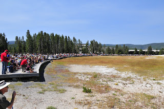
Just a few folks gathered to watch Old Faithful erupt on a Sunday afternoon.
We drove on to Old Faithful.  We saw the crowd was gathering when we finally got parked and walked out to the geyser.  We guessed the expected eruption time was close, but decided to try to make it up to an observation point a half mile from the geyser on the hill side, but in the process missed the eruption.

We hiked on and found Solo geyser which erupts every 4-7 minutes... but you better be watching.  It gives up one really good gush of water and it's over  until the next time.

There is a large field of geysers near Old Faithful, so we wandered the paths (along with a lot of others) watching them bubble and spew in differing sizes and shapes.  Then headed back for the next eruption of Old Faithful.  It is pretty impressive when it goes.
Old Faithful
It was after 2PM and we had to decide if it would be Bozeman or Butte, Montana for the night, so grabbed some lunch at a picnic area and headed north and west.  We decided on Butte simply becuase it would cut driving time the next day.  Butte is an old mining town with a large open pit copper mine just on the north edge... and a "Superfund" site. After dinner and already drinking the water, Beth read all about the years of remediation that has gone on with the water system.


Now on to the Google maps part of the story. 

One of the ways I plan bike rides in a new place is to use the "Bicycling" feature of Google maps.  It will highlight the bike trails with green lines on the map.  So I was checking out Google maps and noticed a large stretch of bike trails a few miles south of town.


Snap-shot of Google Maps near Butte
I use MapMyRide.com to plan routes, see what the distance is and total elevation gains will be.  I laid out a route that would include the major portion of the bike trails on the map from our hotel.  It came up at 30 miles and about 2200' of climbing, so a pretty long morining ride, but doable and Beth was game.

I broke one of my own rules and didn't check the satellite view of Google map to make sure the route was paved.  We were about 7 miles into the ride and 2 miles down a dirt road when a large German shepard came out to "greet" us.  She was very friendly but didn't listen to her owner too well.  We stopped and talked with the guy.  He tells us, in a very friendly way that we are on a private road and yes, there is a gate up ahead into the Thompson Park area.  He said we could ride on, but looked at our road bike and said we might not make it much past a turn-off a half mile ahead or so.  We told him our map showed this as a bike trail just ahead and should connect up with Hwy 2.  He said it used to be an old railroad bed and there are some tunnels futher up, but he wasn't sure how we were going to get the highway. 
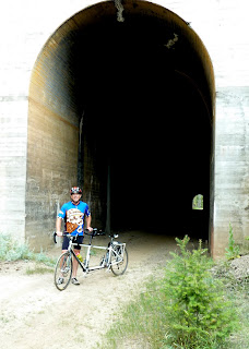
He finally rounded up his shepard and we went on our way up the road which slowly deteriorated from a nice dirt road to overgrown jeep trail.... but it was beautiful country.  The trail slowly climbed up the mountain side and we did find the tunnels.  But no head light or flashlight, made getting through them a little of an adventure of it's own.   I tried using my iPhone "flashlight, but tunnel just seemed to suck up the light.

We kept riding on and my iPhone GPS app (Runmeter) showed we were making steady progress toward Hwy 2.  It finally came into sight.  Intially we were at least 100' above it with a large ravine between us.  As we continued on, we reached the end of the ravine, but the highway was 50' straight above us.  The path seemed to have come to an end, but we found some tire tracks to the right and followed them up a gully to what was part of the path and to the highway. 

There was at least 10 more miles of "bike path" left in our route and at least 2 pretty steep decents.  So we optted for the highway and headed back to Butte.  It was a beautiful descent back down the mountain on the highway.

I am glad that Beth has a great sense of humor and adventure when it comes to some of our bike rides.   This one was a classic.  We laughed about it most of the way to down the hill and into town.
End of the "bike trail"


Saturday, August 4, 2012

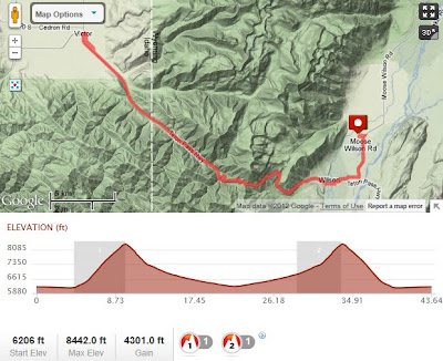
Another really great day of riding in Wilson/Jackson, WY.  We did a challenging ride from our condo in Wilson to Victor, Idaho over the Teton Pass Road ... and back.  Not that Teton Pass is very high, 8100', but it is steep from both sides, 10% grade for 5 miles on the Wilson side and 3 miles on the Idaho side. 
Beth doing her best cowboy impersonation on our return to Wilson, WY.
We have really enjoyed our stay here in the Jackson area.  The condo we rented was really nice and well located. We are planning to leave early tomorrow to go to Yellowstone for a hike and then on toward Coeur d'Alene, ID for another 3 day stay before heading on to Seattle to ride with Jim and Heidi to Winthrop where they got married on Aug 10.


On Wednesday after our ride around Estes Park, CO, we drove to spend the night in Laramie, WY.  We had looked for a motel a little further down the road, but didn't find much... and we when drove through, we didn't see much either.  Southwest Wyoming is a lot like NM, mostly desert.  We took care of few things while in Laramie, like laundry, fixing a turn signal that was out, and cleaning up "Bianca" our road tandem.  It was pretty dirty after the Rocky Mt. National Park ride on dirt road, rain and hail.

We got in a nice ride in Laramie before hitting the road.


When we were driving from Rock Springs, WY to Pinedale we were looking for a roadside park to have lunch.  There isn't much along this 90 mile stretch of road and finally saw a sign for a picnic table along the road.  It turned out to be table next to a half dead tree and an old house that had fallen down. We stopped since we hadn't seen anything for miles.  We were pulling out our lunch when a local guy stopped and told us about a nice small park 2 miles up the road in Eden.  We packed back up and followed him to the park.  It was really nice of him to stop and give us some good advice.

After getting to our condo in Wilson near Jackson, we went to the grocery store to stock up for our visit.  On the way back to the condo, we had our first moose sighting.  We still on the look out for a male, but haven't seen one yet.

On Friday morning we set out on a 68 mile ride throught the Grand Teton National Park.  It was a nice ride with great views.  Not a lot of climbing on this ride, but plenty of wind.  Beth and I were pretty beat by the time we got back to the condo.  The landscape is really diverse from marshlands in the valley, with intermingled sections of sagebrush desert and lush pine forests.

Wednesday, August 1, 2012

Estes Park, CO

We have spent a couple of days in Estes Park, CO.  On our first day here we hiked up Deer Mountain which is was just across the river from our hotel.  The trail head was a few miles away inside the Rocky Mountain National Park.  It was 3 miles to the summit at just over 10,000'.  A really nice hike with great views all around the mountain and a good view of Estes Park from the top.

On our second day at Estes Park, we did a great ride through Rocky Mt National Park, a 36 mile ride up Fall River Rd and back on Trail Ridge Rd.  This would normally be a challenging ride with over 5000' of climbing in the first 18 miles, but we encountered 10 miles of dirt road we weren't planning on, rain, hail and heavy winds in the last 4 miles to the very peak of the ride at 12,100'.  The views were great and we had a really good time, but it goes into the near epic category.  We were both a little sore this morning after such a hard day.

Almost to the end of the dirt road at 11,200' in elevation
For our last day in Estes Park, we did a pretty casual, 18 mile ride from our cabin through Estes Park, by Estes Park Lake and looping through the outskirts of Estes Park.  It was a nice ride to loosen our legs from yesterday's ride.  


After packing up the the car, we drove by to the Stanley Hotel which was used in the Stephen King movie, "The Shining".  We walked around the hotel which has a long history going back to the early 1900's.  


We had a nice lunch by the lake and then drove to Laramie, WY where we are spending the night before driving on to Jackson Hole, WY.

More photos of the past few days of our trip.