Friday, June 9 –
We had designated this as mostly a travel
day and had chosen a route through the San Juan mountains of southwestern CO. This is a route to the park that we had not
traveled before. This is getting harder
to do as so many of our trips head to the northwest. We drove through Creed, CO, an old mining
town. Unlike so many of CO’s mining
towns that mined silver; Creed is the only town that mined bentonite clay. The clay was used in refining oil and frequently used as a desiccant (water absorber) for guns and ammunition and in the production of make-up and
salt water taffy. The mine went out of
business in 1999.
 |
| Head waters of the Rio Grande with the Rio Grande Pyramid in the background |
A pullover on one of the mountain passes outside of Creed
gave us a view of the Rio Grande Pyramid.
Ever wonder where a river starts?
For the Rio Grande, it is here. A
new fact for us is that the Rio Grande is the third longest river in the United
States (1885 miles) after the Mississippi and the Missouri. We have now been to the headwaters of all
three.
 |
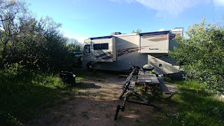
| Our campsite at Black Canyon NP... just the length of our 28' RV |
Late in the afternoon we entered Black Canyon of the
Gunnison National Park. Being one of the
lesser known national parks located near Montrose, CO and being hard to get to
(at least from NM), we were not anticipating any trouble finding a spot in the
campground. Especially since 1/3 of the
spots can’t be reserved. To our
surprise the camp was almost full. Every
“reservation” spot was
taken and we were lucky to find an open, fairly level spot that was just barely big enough for our 28’
RV in the first-come/ first-served
loop. By that evening the campground was
full. A note to the wise; arrive early
or better yet, make a reservation.
taken and we were lucky to find an open, fairly level spot that was just barely big enough for our 28’
 |
| Painted Wall at Black Canyon, the tallest cliff in CO at 2300' from top to bottom |
Saturday, June 10 – We set out on foot for the 1 mile walk
to the Visitor’s Center, followed by a 2 mile loop just below the rim,
finishing back at the campground for a total of 4 miles.
When we returned to the campground, many of the other campers had left
and the remaining people were moving around to better locations. We were able to move the RV to a location
that had fewer trees, making it easier to put out our slide outs.
In the afternoon, we drove down a steep set of switchbacks at the east end of the park to the Gunnison diversion tunnel. The tunnel was drilled starting in 1909 and is 10,000 feet long through solid rock to the valley near Montrose. The tunnel was drilled from both ends and met in the middle. Quite the engineering feat for the time. These are some seriously steep canyons to work in. After our visit to the diversion tunnel we drove the south rim
road, stopping at the Visitors Center and the many pullouts to walk out and look down the canyon.
 |
| At the bottom of Black Canyon near the Gunnison diversion tunnel |
Sunday, June 11 – Our plan for the day was to drive to the
north rim of the canyon. From the
campground it’s a 2 hour drive, backtracking some of Friday’s drive on Hwy 50
before turning onto Hwy 92. East of the
national park is a reservoir (Blue Mesa) which is part of Curecanti National
Recreation Area. The drive to the North
Rim was scenic. And the canyon view from the north rim were spectacular.
The dirt road runs right along the rim and any pullouts brought you to
the edge of the rim. We really enjoyed
the views from this side much more than the south rim. It is a wild and rugged canyon and you can
see why no signs of any human habitation have been found in the canyon. Any activity within the inner canyon,
including hiking, climbing and kayaking, require a wilderness permit and is
highly discouraged unless you are an expert.
 |
| A deer with no fear... came to visit several times |
Monday, June 12, 2017 – After one more night at the
campground, we biked the south rim road.
Although only a little over 14.5 miles round trip, we climbed over 1400 feet at an average elevation of 8000 feet. Quite a nice early morning workout. Then it was onto the task of packing up
everything, putting the bike on the rack and hooking up the jeep for a short
drive to Olathe, Colorado and the Uncompahgre River RV Park. We had stayed here once in the past and
remembered it as a nice place with good laundry facilities. The rest of the day was spent taking care of
the multitude of chores (laundry, grocery shopping, bug removal from the front of the RV, Beth is still working remotely, etc) that have built up when you have been on the road for 7 days, either
boon-docking or in the national park with limited services. It seems a little odd to have pressurized water, 115VAC electricity, WIFI and cable TV available.
 |
| At the high point of the south rim road |
No comments:
Post a Comment